This animation of NOAA's GOES-East satellite imagery from Sept. 30 to Oct. 3 shows major Hurricane Matthew moving through the Caribbean Sea and bearing down on Haiti, Cuba and Jamaica. (NASA)
(This article, originally posted Monday morning, was updated in the evening.)
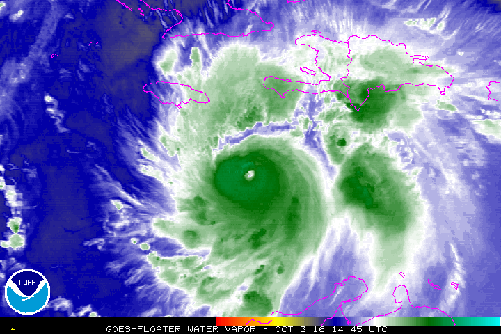
Hurricane Matthew remains an extremely powerful Category 4 hurricane, and it is hours away from producing a prolonged period of life-threatening conditions in parts of Haiti, Cuba and Jamaica. Ultimately, those conditions will extend into the Bahamas.
Some impacts along the U.S. East Coast now appear to be more likely as we look toward the weekend, although there is a large amount of uncertainty. While there is more suggestion of a coastal scrape than a landfall at this time, a U.S. landfall certainly isn’t out of the question.
Florida Governor Rick Scott has declared a State of Emergency as the state could face tropical storm or even hurricane conditions as early as Thursday depending on Matthew’s exact track.
Matthew’s maximum winds are back up to 140 mph after modestly weakening Sunday night. There were signs it was intensifying further Monday evening (hurricane hunter aircraft noted its central pressure was falling) just prior to moving over western Haiti.

Hurricane warnings are in effect for Jamaica, Haiti, eastern Cuba, and the eastern and central Bahamas. The storm is tracking due north at 7 mph, and that slow forward motion will unfortunately keep the high wind and heavy rain over the same areas for an extended amount of time. Some places may be battered for perhaps two days.
Hurricane-force winds extend to roughly 40 miles from Matthew’s center, but tropical storm force winds reach out a sprawling 185 miles.
If the center stays far enough from Jamaica, that nation could avoid the worst of the winds, although heavy rain is still a big concern.
The storm surge along Haiti’s and Cuba’s southern coasts is predicted to be 7 to 11 feet. This is a very real danger must not be overlooked or underestimated. The rainfall forecast for Haiti is especially ominous, but eastern Jamaica and eastern Cuba are not far behind. Parts of Haiti could receive up to 40 inches of rain. This is likely to produce terrible flash floods and mudslides.
“Life-threatening rain…wind…and storm surge expected in parts of Haiti tonight,” headlined the National Hurricane Center’s 5 p.m. advisory.
Haiti has been hit or grazed by numerous very strong hurricanes over the centuries, but even weaker storms that pass nearby have produced devastating floods and mudslides.
Direct landfalls on Haiti, by major hurricanes, include David (1979), Inez (1966), Cleo (1964), Flora (1963) and Hazel (1954). Several other extremely intense storms passed very close, such as Allen (1980). Other recent natural disasters include the 2008 hurricane season when hurricanes Fay, Gustav, Hanna and Ike all ravaged the country, and then the infamous 2010 earthquake. It currently seems unfortunately likely that Matthew will become an addition to that grim list.
Looking beyond the next three days of continuous island encounters, Matthew’s longer-range track still keeps the U.S. East Coast in play.
While prolonged full-blown hurricane conditions are unlikely in Florida, a slight westward nudge in the track could bring hurricane conditions to parts of Florida’s east coast. The percent chance of tropical storm conditions has grown to greater than 50-50 in the easternmost areas and the National Hurricane Center, in its 5 p.m. update, said “direct hurricane impacts are possible.”

Hurricane or tropical storm watches may be issued for Florida’s east coast Monday night or Tuesday.
Looking further ahead to Friday and the weekend, the southeast United States, the Mid-Atlantic states and the northeast are certainly still at risk. Even if the storm remains offshore, it could be close enough to produce storm surges and coastal erosion.
The American GFS model predicts Matthew will hug the Southeast and Mid-Atlantic coast with considerable wind and rain, even as far west as the Interstate 95 corridor.

The European (ECMWF) model, alternatively, forecasts Matthew will come uncomfortably close to the coast but remain offshore. It would bring more of a glancing blow to coastal areas.

The timing and strength of a subtropical ridge to the east of Matthew will determine if the storm will continue out to sea or if it will make landfall first and then get pushed out by the next cold front.
Matthew has now been a major hurricane for over 72 hours, and has had winds of at least 140 mph for a much of that time. CWG’s tropical analyst Phil Klotzbach points out that this is the longest we’ve had such a strong storm in the Atlantic Ocean on record:
Prior to Matthew’s formation, the season’s Accumulated Cyclone Energy (ACE) was at approximately 70 percent of an average season for the date. As of today, the season is at about 89 percent of average for this date. ACE is a metric that takes into account both the intensity and the longevity of tropical cyclones, so a long-lived strong hurricane will make a big contribution.
With Matthew expected to continue churning for at least a week to 10 days, these ACE numbers will continue to rise. The storm’s overall toll will increase as well, as it begins to impact population in a way it has not done to this point.

(Jason Samenow and Ian Livingston contributed to this post.)
Click here to view original web page at www.washingtonpost.com